 |
 |
|
|
The layout of the Via Francigena in its Italian section is sketched with the entrance of the Longobards at the end of the seventh century. The Longobard Kingdom was centered in Pavia and needed a connection with their Dukedoms at the center and southern parts of Italy. They needed a road secure from raids of the Byzantines or the Roman East Empire. The Byzantines belonged to the empire of east, in the territories of the "Esarcato of Ravenna" and the two "Pentapolis". The Byzantines monitored the passage of oriental travelers of Appennino. These travelers would cross using Roman roads like The Florence-Faenza. These passages were located in the territories along the tall Adriatic on which the consulars Roman roads Flaminia and Popilia were not monitored. To cross the Appennino tosco-emiliano, the Longobards were therefore forced to choose the layout of the ancient Roman Road Parma-Lucca as well as the Via Aemilia Scauri. The road of the Bardone Mountain was called (the Mons Langobardorum, now Cisa Pass), it was the artery that gave origin to the future Francigena Road. After the conquest of the Lunigiana, the Byzantine territories grew outward from the Ligure Sea, the road of the Bardone mountain was equipped and made easier to travel. Meanwhile the Road was starting to be crossed by the troops from the Longobard population. The road was also being used by the arriving pilgrims from the southwest of Europe and from the British Islands that were traveling toward Rome or Jerusalem.
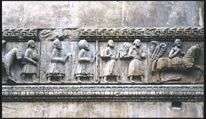
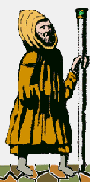
The Via Francigena assisted in Europe's general renewing of spirit that adds to a demographic increase, and to a progressive economic comfort. The development of the Via Francigena is due to the different positive exchanges of pilgrimages. The Via Francigena has involved "in primis " of it. Shortly the Road, therefore, became the more important European road of the Middle Ages, the principal "high way" between the cities of the northwest of Europe and the Roman capital. At one point of only the Roman Empire and now of all Christianity. The Via Francigena has been crossed by merchants, pilgrims, by kings and armies. At the end of 1000 AD it was use by knights and Crusaders coming from "ultra Alps" to regain the Saint Sepulchre. The trip toward the tomb of the apostles Pietro and Paul united the rich man to the poor man, the prelate to the wandering pilgrim. The Via Francigena dealt with an authentic adventure. It was studded with traps, dangers and natural obstacles, but was regarded also as a walk of purification, as well as a walk of discovery in the search of a new man. The Road didn't maintain the aboriginal run, but during the years it changed more times from different political, physical, atmospheric factors.
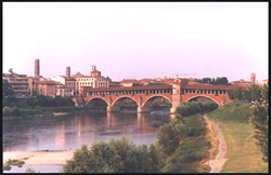
The Archbishop Sigerico reached the Urbe in July and stayed only two days, just long enough to meet with Pope Giovanni XV and to quickly visit the churches of the eternal city. The Archbishop Sigerico write of his return journey named the "submansiones de Rome usque ad mare". The Archbishop told and chronicled eighty places, from the Urbe to English Channel. Among these places were big cities and small suburbs, some of which disappeared many centuries ago. The best know transcripts of the Archbishops journey, which references are made in his itinerary are: Arras, Reims, Pontarlier, Besançon, Lausanne, Martigny, the Big St. Bernard Pass, Aosta, Ivrea, Vercelli, Pavia, Piacenza, Fidenza, the footstep of the Cisa, Pontremoli, Massa, Lucca, San Gimignano, Siena, Bolsena, Rome. An average trip on The Via Francigena covered about thirty kilometers a day. This was done mainly on foot. The more fortunate people would cross by mule. While the most powerful and prestigious people, such as Kings, would travel this road by horse.
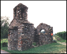
This normally offered a pilgrim a roof over their head, some straw to sleep on and sometimes a frugal meal. During 1200 AD, after centuries of forgetfulness or lack of local use entirely, travelers started bypassing the Pass of the Central-Eastern Alps. First between the whole Brennero Pass using other passes of the Appennini, giving origin to the new current traffic of pilgrims and merchants. These new passes lead to the decay of the Via Francigena, which in turn removed it from being a road line that was a important national artery of regional value.
|